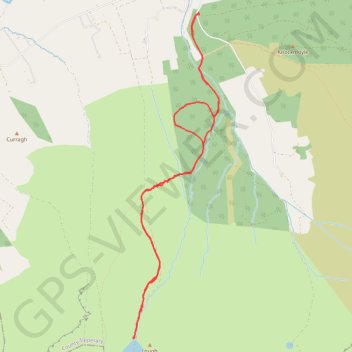
Lough Curra
#Hike
- Distance: 9.5 Km
- Elevation gain: 443 m
- Maximum elevation: 577 m
- Elevation loss: 445 m
- Minimum elevation: 136 m
Interactive map
GPS track profile
About this GPS track
Name: Lough Curra GPS track, route, trail
Coordinates: 52.37025 -8.19537 52.40194 -8.18168
Topography: County Tipperary topographic map
Other GPS tracks
Click on a GPS track to view route, its statistics and profile.
Trace IRELAND
Distance: 1,506.7 Km • Elevation gain: 13,359 m • Maximum elevation: 524 m
RT5-1 Rosslare - Kinsale
Distance: 2,860.3 Km • Elevation gain: 27,381 m • Maximum elevation: 420 m
RT5-1 Rosslare - Kinsale
Distance: 3,867.1 Km • Elevation gain: 36,115 m • Maximum elevation: 524 m
RT5-1 Rosslare - Kinsale
Distance: 1,353.5 Km • Elevation gain: 15,245 m • Maximum elevation: 420 m
TT22 J3 M1/06 : Port de Cork à Dublin
Distance: 358.2 Km • Elevation gain: 4,279 m • Maximum elevation: 524 m
Thurles - Cork
Ireland > County Tipperary > Thurles
#Bike
Distance: 129.7 Km • Elevation gain: 1,137 m • Maximum elevation: 237 m