GPS tracks, routes, trails, hikes

GPS tracks visualization and sharing, free and without registration.

Import a GPX file

Cliffs of Moher - Stookeen Cliff

#Hike

  • Distance: 22.5 Km
  • Elevation gain: 1,134 m
  • Maximum elevation: 192 m
  • Elevation loss: 1,148 m
  • Minimum elevation: 1 m

Interactive map

GPS track profile

About this GPS track

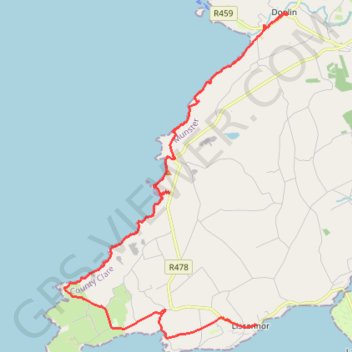
Name: Cliffs of Moher - Stookeen Cliff GPS track, route, trail.
Start: Hotel Doolin Complex, R479, Doolin, Killilagh ED, West Clare Municipal District, County Clare, Munster, V95-V9P1, Ireland (53.01582 -9.37616)
End: Liscannor Hotel, R478, Liscannor, Liscannor ED, West Clare Municipal District, County Clare, Munster, V95KR28, Ireland (52.93870 -9.38905)
Coordinates: 52.93538 -9.46812 53.01609 -9.37616

Other GPS tracks

Trace IRELAND

Irlande > Comté de Wexford

Distance: 1,506.8 Km - Elevation gain: 13,240 m - Maximum elevation: 525 m - Coordinates: 51.47470 -10.38119 53.59998 -6.16127

Start: N25, St. Helen's ED, The Borough District of Wexford, Comté de Wexford, Leinster, Irlande (52.25081 -6.33460)

RT5-1 Rosslare - Kinsale

Irlande > Comté de Wexford

Distance: 3,865.0 Km - Elevation gain: 35,614 m - Maximum elevation: 525 m - Coordinates: 51.45367 -10.46666 55.38103 -5.98290

Start: N25, St. Helen's ED, The Borough District of Wexford, Comté de Wexford, Leinster, Irlande (52.25133 -6.34150)

End: Carrigaline ED, Municipal District of Carrigaline, Comté de Cork, Munster, P43 A062, Irlande (51.83246 -8.31793)

Tour de l'Irlande : Cork - Waterford

Irlande > County Cork > Cork

#Irlande #Boucle

Distance: 1,137.1 Km - Elevation gain: 8,200 m - Maximum elevation: 299 m - Coordinates: 51.84812 -9.97454 55.04007 -5.91264

Start: 1, Grand Parade, City Centre, Centre A ED, Cork, County Cork, Munster, T12 NC8Y, Irlande (51.89851 -8.47560)

End: Waterford Boat Club, Scotch Quay, Park, Waterford City Metropolitan District, County Waterford, Munster, X91 VXEO, Irlande (52.25852 -7.10202)

RT5-1 Rosslare - Kinsale

Irlande > Comté de Wexford

Distance: 2,860.2 Km - Elevation gain: 26,863 m - Maximum elevation: 416 m - Coordinates: 51.45303 -10.46666 55.38103 -6.34150

Start: N25, St. Helen's ED, The Borough District of Wexford, Comté de Wexford, Leinster, Irlande (52.25133 -6.34150)

End: Ardmalin ED, Inishowen Municipal District, County Donegal, Irlande (55.38103 -7.37378)

RT5-1 Rosslare - Kinsale

Irlande > Comté de Wexford

Distance: 1,352.8 Km - Elevation gain: 15,046 m - Maximum elevation: 416 m - Coordinates: 51.45211 -10.46666 53.01608 -6.34150

Start: N25, St. Helen's ED, The Borough District of Wexford, Comté de Wexford, Leinster, Irlande (52.25133 -6.34150)

End: Hotel Doolin Complex, R479, Fitz's Cross, Doolin, Killilagh ED, West Clare Municipal District, Comté de Clare, Munster, V95 DE2X, Irlande (53.01608 -9.37741)