Royal canal way
#Bike
- Distance: 43.7 Km
- Elevation gain: 98 m
- Maximum elevation: 81 m
- Elevation loss: 163 m
- Minimum elevation: 10 m
Interactive map
GPS track profile
About this GPS track
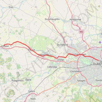
Name: Royal canal way GPS track, route, trail
Coordinates: 53.36160 -6.83618 53.42977 -6.25845
Topography: County Meath topographic map
Other GPS tracks
Click on a GPS track to view route, its statistics and profile.
Trace IRELAND
Distance: 1,506.7 Km • Elevation gain: 13,359 m • Maximum elevation: 524 m
RT5-1 Rosslare - Kinsale
Distance: 2,860.3 Km • Elevation gain: 27,381 m • Maximum elevation: 420 m
TT22 J4 J2/06 : Dublin à Belfast
Irlande > County Dublin > Dublin
Distance: 250.3 Km • Elevation gain: 2,609 m • Maximum elevation: 390 m
RT5-1 Rosslare - Kinsale
Distance: 3,867.1 Km • Elevation gain: 36,115 m • Maximum elevation: 524 m