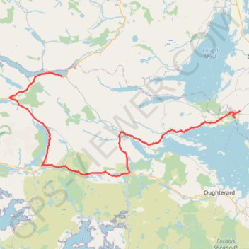
GPS tracks visualization and sharing, free and without registration.
#Bike
Randonnée pédestre. En boucle. #Randonnée #Boucle
Distance: 16.4 Km - Elevation gain: 327 m - Maximum elevation: 80 m - Total time: 3 h 59 m - Date: 04/07/10 - Coordinates: 53.58158 -9.86011 53.62055 -9.78077
Start: Bunowen, Cushkillary ED, Conamara Municipal District, County Galway, Connacht, Irlande (53.59206 -9.78856)
Distance: 1,506.8 Km - Elevation gain: 13,240 m - Maximum elevation: 525 m - Coordinates: 51.47470 -10.38119 53.59998 -6.16127
Start: N25, St. Helen's ED, The Borough District of Wexford, Comté de Wexford, Leinster, Irlande (52.25081 -6.33460)
Distance: 3,865.0 Km - Elevation gain: 35,614 m - Maximum elevation: 525 m - Coordinates: 51.45367 -10.46666 55.38103 -5.98290
Start: N25, St. Helen's ED, The Borough District of Wexford, Comté de Wexford, Leinster, Irlande (52.25133 -6.34150)
End: Carrigaline ED, Municipal District of Carrigaline, Comté de Cork, Munster, P43 A062, Irlande (51.83246 -8.31793)
Randonnée pédestre. En aller-retour. #Randonnée
Distance: 3.0 Km - Elevation gain: 225 m - Maximum elevation: 386 m - Total time: 54 m 19 s - Date: 04/07/10 - Coordinates: 53.52719 -9.41853 53.53070 -9.39935
Start: Gortnarup, Cloonbur ED, Conamara Municipal District, County Galway, Connacht, Irlande (53.52740 -9.39935)
End: Ballard, Cloonbur ED, Conamara Municipal District, County Galway, Connacht, Irlande (53.52738 -9.39956)
Ireland > County Galway > Leenaun
#Bike
Distance: 62.2 Km - Elevation gain: 612 m - Maximum elevation: 79 m - Coordinates: 53.59432 -9.89946 53.79892 -9.51670
Start: Leenane Hotel, N59, Leenaun, Letterbrickaun ED, Conamara Municipal District, County Galway, Connacht, H91W1W4, Ireland (53.59482 -9.70526)
End: Scoil Padriag, Altamont Street, Westport Urban Electoral Division, Westport-Belmullet Municipal District, County Mayo, Connacht, F28 RD39, Ireland (53.79863 -9.51670)
Irlande > County Cork > Cork
Distance: 1,137.1 Km - Elevation gain: 8,200 m - Maximum elevation: 299 m - Coordinates: 51.84812 -9.97454 55.04007 -5.91264
Start: 1, Grand Parade, City Centre, Centre A ED, Cork, County Cork, Munster, T12 NC8Y, Irlande (51.89851 -8.47560)
End: Waterford Boat Club, Scotch Quay, Park, Waterford City Metropolitan District, County Waterford, Munster, X91 VXEO, Irlande (52.25852 -7.10202)
Distance: 2,860.2 Km - Elevation gain: 26,863 m - Maximum elevation: 416 m - Coordinates: 51.45303 -10.46666 55.38103 -6.34150
Start: N25, St. Helen's ED, The Borough District of Wexford, Comté de Wexford, Leinster, Irlande (52.25133 -6.34150)
End: Ardmalin ED, Inishowen Municipal District, County Donegal, Irlande (55.38103 -7.37378)
#Bike
Distance: 62.5 Km - Elevation gain: 852 m - Maximum elevation: 289 m - Coordinates: 53.53136 -9.52260 53.79902 -9.27260
Start: Scoil Padriag, Altamont Street, Westport Urban Electoral Division, Westport-Belmullet Municipal District, County Mayo, Connacht, F28 RD39, Ireland (53.79883 -9.51692)
End: R345, Gortaroe, Cong Electoral Division, Claremorris-Swinford Municipal District, County Mayo, Connacht, F31XD56, Ireland (53.54477 -9.27260)
Ireland > County Galway > Leenaun
#Bike
Distance: 50.3 Km - Elevation gain: 575 m - Maximum elevation: 75 m - Coordinates: 53.55305 -9.98560 53.60901 -9.70525
Start: Leenane Hotel, N59, Leenaun, Letterbrickaun ED, Conamara Municipal District, County Galway, Connacht, H91W1W4, Ireland (53.59496 -9.70525)