Blessington
Interactive map
GPS track profile
About this GPS track
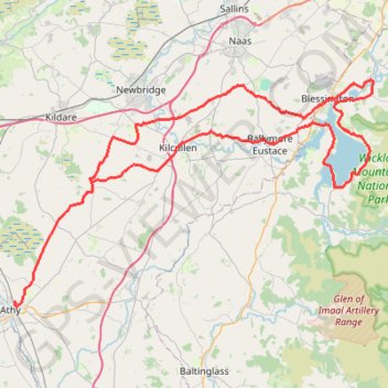
Name: Blessington GPS track, route, trail
Coordinates: 52.99387 -6.97743 53.18740 -6.46837
Topography: County Kildare topographic map
Other GPS tracks
Click on a GPS track to view route, its statistics and profile.
Trace IRELAND
Distance: 1,506.7 Km • Elevation gain: 13,359 m • Maximum elevation: 524 m
RT5-1 Rosslare - Kinsale
Distance: 2,860.3 Km • Elevation gain: 27,381 m • Maximum elevation: 420 m
RT5-1 Rosslare - Kinsale
Distance: 3,867.1 Km • Elevation gain: 36,115 m • Maximum elevation: 524 m
RT5-1 Rosslare - Kinsale
Distance: 1,353.5 Km • Elevation gain: 15,245 m • Maximum elevation: 420 m
TT22 J3 M1/06 : Port de Cork à Dublin
Distance: 358.2 Km • Elevation gain: 4,279 m • Maximum elevation: 524 m
Athy - Durrow
#Bike
Distance: 41.1 Km • Elevation gain: 354 m • Maximum elevation: 190 m