Dog Falls and Coire Loch, Glen Affric
GPX file from Walkhighlands; file is copyright Walkhighlands and must not be publicly shared on other websites. Do not remove this notice.
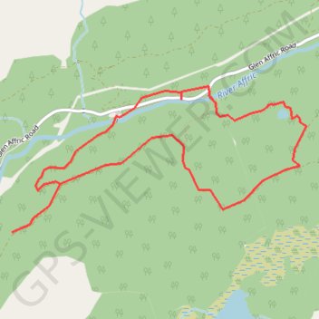
- Distance: 6.1 Km
- Elevation gain: 220 m
- Maximum elevation: 306 m
- Elevation loss: 220 m
- Minimum elevation: 177 m
Interactive map
GPS track profile
About this GPS track
Name: Dog Falls and Coire Loch, Glen Affric GPS track, route, trail
Start: Dog Falls carpark, Glen Affric Road, Highland, Écosse, IV4 7LY, Royaume-Uni (57.31243 -4.85223)
End: Dog Falls carpark, Glen Affric Road, Highland, Écosse, IV4 7LY, Royaume-Uni (57.31242 -4.85222)
Coordinates: 57.30554 -4.86371 57.31420 -4.83128