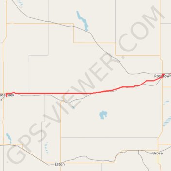
Kindersley - Rosetown
- Distance: 86.0 Km
- Elevation gain: 184 m
- Maximum elevation: 699 m
- Elevation loss: 277 m
- Minimum elevation: 584 m
Interactive map
GPS track profile
About this GPS track
Name: Kindersley - Rosetown GPS track, route, trail
Start: Ditson Drive, Kindersley, Division No. 13, Saskatchewan, S0L 1S0, Canada (51.46016 -109.14492)
Coordinates: 51.46016 -109.14492 51.56210 -107.97900
Other GPS tracks
Click on a GPS track to view route, its statistics and profile.
Oyen - Kindersley
Canada > Alberta > Division No. 4
#Bike #Oyen #Kindersley
Distance: 97.8 Km • Elevation gain: 314 m • Maximum elevation: 773 m