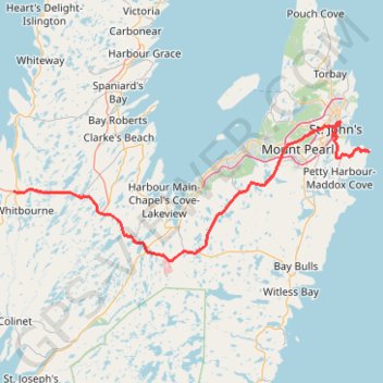
Whitbourne - St. John's
#Bike #Whitbourne #StJohns #Newfoundland #Atlantic
- Distance: 103.3 Km
- Elevation gain: 1,230 m
- Maximum elevation: 234 m
- Elevation loss: 1,222 m
- Minimum elevation: 0 m
Interactive map
GPS track profile
About this GPS track
Name: Whitbourne - St. John's GPS track, route, trail
End: Cape Spear Path, St. John's, Newfoundland, Newfoundland and Labrador, Canada (47.51998 -52.62413)
Coordinates: 47.32630 -53.55229 47.57163 -52.62413
Other GPS tracks
Click on a GPS track to view route, its statistics and profile.
East Coast Trail - Spout Path
Canada > Newfoundland and Labrador > St. John's
Distance: 22.0 Km • Elevation gain: 854 m • Maximum elevation: 180 m
St. Johns - Signal Hill - Quidi Vidi
Canada > Newfoundland and Labrador > St. John's
Signal Hill National Historic Site. #Hike #SignalHill #Atlantic
Distance: 5.9 Km • Elevation gain: 284 m • Maximum elevation: 149 m
Argentia - Whitbourne
Canada > Newfoundland and Labrador > Placentia
Distance: 45.9 Km • Elevation gain: 453 m • Maximum elevation: 183 m
East Coast Trail - Deadmans Bay Path
Canada > Newfoundland and Labrador > St. John's
Distance: 10.0 Km • Elevation gain: 440 m • Maximum elevation: 220 m
East Coast Trail - Cape Spear Path
Canada > Newfoundland and Labrador > Petty Harbour-Maddox Cove
Distance: 11.0 Km • Elevation gain: 288 m • Maximum elevation: 89 m
Arnold's Cove - Whitbourne
Canada > Newfoundland and Labrador
#Bike #ArnoldsCove #Whitbourne #Newfoundland
Distance: 50.5 Km • Elevation gain: 719 m • Maximum elevation: 199 m