Bamberton Provincial Park - Nanaimo
Interactive map
GPS track profile
About this GPS track
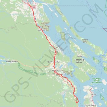
Name: Bamberton Provincial Park - Nanaimo GPS track, route, trail
Coordinates: 48.60568 -123.92127 49.13107 -123.52111
Other GPS tracks
Click on a GPS track to view route, its statistics and profile.
Genoa Bay - Mad Dog Trail
Canada > British Columbia > Cowichan Valley Regional District > North Cowichan
Mount Tzouhalem Ecological Reserve. Vancouver Island. #Hike #MountTzouhalem #Vancouver
Distance: 6.4 Km • Elevation gain: 521 m • Maximum elevation: 486 m
Stoney Hill Loop
Canada > British Columbia > Cowichan Valley Regional District > North Cowichan
Stoney Hill Regional Park. Vancouver Island. #Hike #Loop #StoneyHill #Vancouver
Distance: 3.7 Km • Elevation gain: 185 m • Maximum elevation: 201 m
Osborne Bay Regional Park - Blue Trail
Canada > British Columbia > Cowichan Valley Regional District > North Cowichan
North Cowichan Municipal Forest Reserve. #Hike #Run #OsborneBay #NorthCowichan
Distance: 8.8 Km • Elevation gain: 433 m • Maximum elevation: 246 m
Mount Prevost
Canada > British Columbia > Cowichan Valley Regional District > North Cowichan
North Cowichan Municipal Forest Reserve. Vancouver Island. #Hike #Loop #NorthCowichan #Vancouver
Distance: 10.8 Km • Elevation gain: 702 m • Maximum elevation: 748 m
Christie Falls - Camas Ridge
Canada > British Columbia > Cowichan Valley Regional District > Area H (North Oyster / Diamond)
#Hike
Distance: 12.5 Km • Elevation gain: 270 m • Maximum elevation: 164 m
Cobble Hill Mountain Regional Recreation Area
Canada > British Columbia > Cowichan Valley Regional District > Area C (Cobble Hill) > Cobble Hill
#Hike #Loop #CobbleHill
Distance: 3.6 Km • Elevation gain: 223 m • Maximum elevation: 314 m
Cobble Hill Loop
Canada > British Columbia > Cowichan Valley Regional District > Area C (Cobble Hill) > Cobble Hill
Cobble Hill Mountain Regional Recreation Area. #Hike #MTB #Loop #CobbleHill
Distance: 7.2 Km • Elevation gain: 325 m • Maximum elevation: 320 m