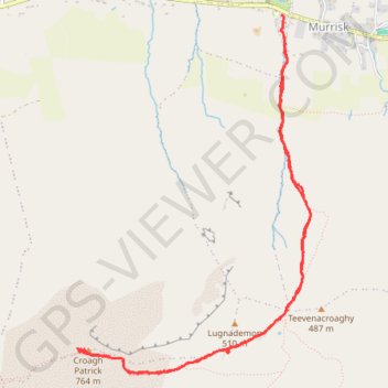
GPS tracks, routes, trails, hikes

GPS tracks visualization and sharing, free and without registration.

Import a GPX file

Croagh Patrick

#Hike

  • Distance: 7.7 Km
  • Elevation gain: 731 m
  • Maximum elevation: 748 m
  • Elevation loss: 724 m
  • Minimum elevation: 17 m
  • Moving time: 2 h 52 m
  • Moving speed: 2.7 Km/h
  • Maximum speed: 7.1 Km/h
  • Total time: 4 h 16 m
  • Global speed: 1.8 Km/h
  • Date: 30/06/18

Interactive map

GPS track profile

About this GPS track

Name: Croagh Patrick GPS track, route, trail.
Start: Murrisk National School, R335, Croaghpatrick Electoral Division, Westport-Belmullet Municipal District, County Mayo, Connacht, Ireland (53.77966 -9.64008)
End: Croagh Patrick Information Centre, Croagh Patrick Pilgrim Trail, Croaghpatrick Electoral Division, Westport-Belmullet Municipal District, County Mayo, Connacht, Ireland (53.77822 -9.63968)
Coordinates: 53.75867 -9.66025 53.77971 -9.63709

Other GPS tracks

RT5-1 Rosslare - Kinsale

Irlande > Comté de Wexford

Distance: 3,865.0 Km - Elevation gain: 35,614 m - Maximum elevation: 525 m - Coordinates: 51.45367 -10.46666 55.38103 -5.98290

Start: N25, St. Helen's ED, The Borough District of Wexford, Comté de Wexford, Leinster, Irlande (52.25133 -6.34150)

End: Carrigaline ED, Municipal District of Carrigaline, Comté de Cork, Munster, P43 A062, Irlande (51.83246 -8.31793)

Connemara - Day 1

Ireland > County Galway > Leenaun

#Bike

Distance: 62.2 Km - Elevation gain: 612 m - Maximum elevation: 79 m - Coordinates: 53.59432 -9.89946 53.79892 -9.51670

Start: Leenane Hotel, N59, Leenaun, Letterbrickaun ED, Conamara Municipal District, County Galway, Connacht, H91W1W4, Ireland (53.59482 -9.70526)

End: Scoil Padriag, Altamont Street, Westport Urban Electoral Division, Westport-Belmullet Municipal District, County Mayo, Connacht, F28 RD39, Ireland (53.79863 -9.51670)

Tour de l'Irlande : Cork - Waterford

Irlande > County Cork > Cork

#Irlande #Boucle

Distance: 1,137.1 Km - Elevation gain: 8,200 m - Maximum elevation: 299 m - Coordinates: 51.84812 -9.97454 55.04007 -5.91264

Start: 1, Grand Parade, City Centre, Centre A ED, Cork, County Cork, Munster, T12 NC8Y, Irlande (51.89851 -8.47560)

End: Waterford Boat Club, Scotch Quay, Park, Waterford City Metropolitan District, County Waterford, Munster, X91 VXEO, Irlande (52.25852 -7.10202)

RT5-1 Rosslare - Kinsale

Irlande > Comté de Wexford

Distance: 2,860.2 Km - Elevation gain: 26,863 m - Maximum elevation: 416 m - Coordinates: 51.45303 -10.46666 55.38103 -6.34150

Start: N25, St. Helen's ED, The Borough District of Wexford, Comté de Wexford, Leinster, Irlande (52.25133 -6.34150)

End: Ardmalin ED, Inishowen Municipal District, County Donegal, Irlande (55.38103 -7.37378)