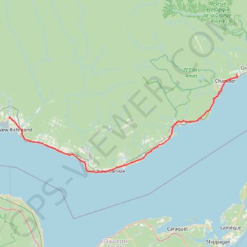
Saint-François-de-Pabos - New Richmond
Gulf of Saint Lawrence. #Bike #SaintFrançoisDePabos #NewRichmond #SaintLawrence #Atlantic
- Distance: 127.3 Km
- Elevation gain: 929 m
- Maximum elevation: 97 m
- Elevation loss: 928 m
- Minimum elevation: -1 m
Interactive map
GPS track profile
About this GPS track
Name: Saint-François-de-Pabos - New Richmond GPS track, route, trail
Coordinates: 48.00237 -65.89930 48.37136 -64.60886
Other GPS tracks
Click on a GPS track to view route, its statistics and profile.
Campbellton - Bathurst
Canada > Quebec > Avignon > Pointe-à-la-Croix > Cross Point Station
Ristigouche River. Gulf of Saint Lawrence. #Bike #Campbellton #Bathurst #Ristigouche #SaintLawrence
Distance: 119.2 Km • Elevation gain: 668 m • Maximum elevation: 69 m
Saint-Georges-de-Malbaie - Saint-François-de-Pabos
Canada > Quebec > Le Rocher-Percé > Percé > Saint-Georges-de-Malbaie > Pointe-Saint-Pierre
Gulf of Saint Lawrence. #Bike #SaintLawrence #Atlantic
Distance: 68.7 Km • Elevation gain: 700 m • Maximum elevation: 142 m