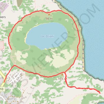
Tour du Lac Dziani (Mayotte)
- Distance: 5.2 Km
- Elevation gain: 153 m
- Maximum elevation: 94 m
- Elevation loss: 178 m
- Minimum elevation: 25 m
Interactive map
GPS track profile
About this GPS track
Name: Tour du Lac Dziani (Mayotte) GPS track, route, trail
Start: Sentier Cratère Dziani, Les Badamiers, Dzaoudzi, Mayotte, 97510, France (-12.77259 45.28331)
Coordinates: -12.77887 45.28214 -12.76699 45.29627
Other GPS tracks
Click on a GPS track to view route, its statistics and profile.