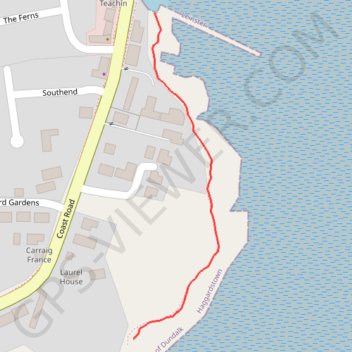
Footpath
- Distance: 0.4 Km
- Elevation gain: 2 m
- Maximum elevation: 3 m
- Elevation loss: 3 m
- Minimum elevation: 0 m
- Moving time: 4 m 26 s
- Moving speed: 5.3 Km/h
- Maximum speed: 6.6 Km/h
- Total time: 4 m 26 s
- Global speed: 5.3 Km/h
- Date: 04/05/24
Interactive map
GPS track profile
About this GPS track
Name: Footpath GPS track, route, trail
Coordinates: 53.95765 -6.36711 53.96057 -6.36581
Topography: County Louth topographic map
Other GPS tracks
Click on a GPS track to view route, its statistics and profile.
RT5-1 Rosslare - Kinsale
Distance: 2,860.3 Km • Elevation gain: 27,381 m • Maximum elevation: 420 m
TT22 J4 J2/06 : Dublin à Belfast
Irlande > County Dublin > Dublin
Distance: 250.3 Km • Elevation gain: 2,609 m • Maximum elevation: 390 m
RT5-1 Rosslare - Kinsale
Distance: 3,867.1 Km • Elevation gain: 36,115 m • Maximum elevation: 524 m