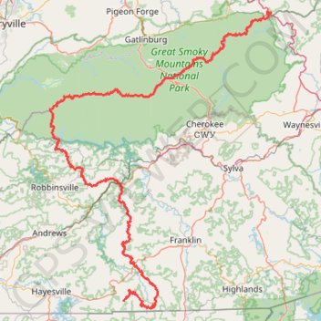
Great Smoky Mountains Appalachian Trail
Hike through Great Smoky Mountains along Appalachian Trail via Standing Indian, Ridgepole Mountain, Yellow Bald, Wine Spring Bald, Copper Ridge Bald, Cheoah Bald, Wauchecha Bald, Fontana Dam, Thunderhead Mountain, Clingmans Dome, Mount Kephart and Mount Guyot. #Hike #Mountain #Nature #Forest #Lake #Appalachian
- Distance: 231.7 Km
- Elevation gain: 8,873 m
- Maximum elevation: 2,013 m
- Elevation loss: 9,716 m
- Minimum elevation: 430 m
- Moving time: 3 d 7 h
- Moving speed: 2.9 Km/h
- Maximum speed: 58.5 Km/h
- Total time: 12 d 13 h
- Global speed: 0.8 Km/h
- Date: 27/01/16
Interactive map
GPS track profile
About this GPS track
Name: Great Smoky Mountains Appalachian Trail GPS track, route, trail
Coordinates: 34.99901 -83.82150 35.78614 -83.10171
Other GPS tracks
Click on a GPS track to view route, its statistics and profile.
Franklin - Lee Creek - Rainbow Springs
United States > North Carolina > Macon County > Franklin
Distance: 76.4 Km • Elevation gain: 2,367 m • Maximum elevation: 1,199 m
Mount Le Conte - High Top
United States > Tennessee > Sevier County
Hike from Alum Cave Bluffs Trailhead to Mount Le Conte via Walker Camp Prong, Alum Cave Trail, Peregrine Peak, Cliff Top, Bull Head Trail and Boulevard Trail in the Great Smoky Mountains National Park. #Hike #Mountain #Nature #Forest
Distance: 18.0 Km • Elevation gain: 1,406 m • Maximum elevation: 1,994 m