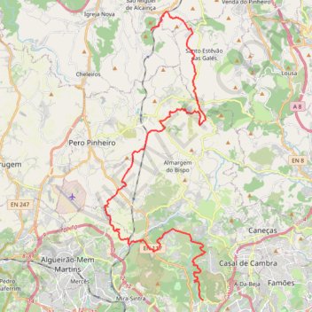
Belas-Moinhos
- Distance: 34.7 Km
- Elevation gain: 767 m
- Maximum elevation: 327 m
- Elevation loss: 773 m
- Minimum elevation: 149 m
- Moving time: 1 h 51 m
- Moving speed: 18.7 Km/h
- Maximum speed: 64.5 Km/h
- Total time: 7 d 2 h
- Global speed: 0.2 Km/h
- Date: 29/01/17
Interactive map
GPS track profile
About this GPS track
Name: Belas-Moinhos GPS track, route, trail
End: Moinhos, Igreja Nova e Cheleiros, Mafra, Lisbon, 2640-302, Portugal (38.90980 -9.28937)
Coordinates: 38.78296 -9.31722 38.91864 -9.25566
Other GPS tracks
Click on a GPS track to view route, its statistics and profile.
Eurovelo 01 Spain + Portugal
France > Nouvelle-Aquitaine > Pyrénées-Atlantiques > Hendaye
Distance: 3,107.2 Km • Elevation gain: 30,592 m • Maximum elevation: 1,503 m
01: Lisboa – Azenhas do Mar (Developed)
Portugal > Lisbonne > Lisbonne
Developed
Distance: 55.2 Km • Elevation gain: 592 m • Maximum elevation: 254 m
Gradil twists
Passeio ate Mafra via Gradil
Distance: 51.5 Km • Elevation gain: 1,051 m • Maximum elevation: 317 m