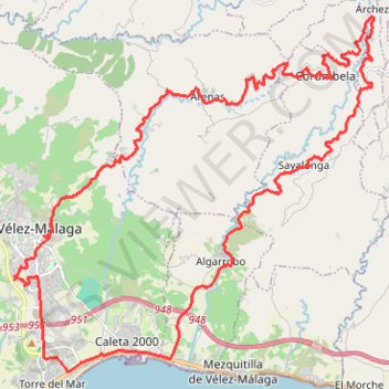
Vélez-Málaga-Arenas-Daimalos-Corumbela-Árchez-Sayalonga-Alga...
- Distance: 45.8 Km
- Elevation gain: 1,245 m
- Maximum elevation: 602 m
- Elevation loss: 1,246 m
- Minimum elevation: 1 m
- Moving time: 2 h 59 m
- Moving speed: 15.3 Km/h
- Maximum speed: 44.6 Km/h
- Total time: 3 h 7 m
- Global speed: 14.6 Km/h
- Date: 31/08/15
Interactive map
GPS track profile
About this GPS track
Name: Vélez-Málaga-Arenas-Daimalos-Corumbela-Árchez-Sayalonga-Alga... GPS track, route, trail
Coordinates: 36.74433 -4.10685 36.83670 -3.98997
Other GPS tracks
Click on a GPS track to view route, its statistics and profile.
Southern Section — European Divide Trail
Espagne > Andalousie > Cazorla
Distance: 830.4 Km • Elevation gain: 19,253 m • Maximum elevation: 2,134 m
Vila do Bispo -> Distrito 4 (495,2 km)
Distance: 1,306.4 Km • Elevation gain: 23,128 m • Maximum elevation: 2,134 m
Torre del Mar - La Buitrera
Espagne > Andalousie > La Axarquía > Vélez-Málaga > Torre del Mar
Distance: 52.2 Km • Elevation gain: 1,616 m • Maximum elevation: 810 m
Velez/competa (por Torrox y casa de la mina)
Espagne > Andalousie > La Axarquía > Vélez-Málaga
Distance: 64.0 Km • Elevation gain: 1,947 m • Maximum elevation: 951 m
Velez/Buitrera de sedella/pasada granadillos/velez
Espagne > Andalousie > La Axarquía > Vélez-Málaga
Distance: 46.9 Km • Elevation gain: 1,884 m • Maximum elevation: 910 m
Cortijo hasta Sedella y vuelta.
Espagne > Andalousie > La Axarquía > Algarrobo-Costa
Distance: 54.7 Km • Elevation gain: 2,378 m • Maximum elevation: 796 m