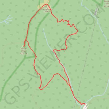
Mount Moosilauke and South Peak Loop
Loop hike from Moosilauke Ravine to Mount Moosilauke via Gorge Brook Trail, Carriage Road, South Peak Spur and Snapper Trail in the White Mountain National Forest. #Hike #Loop #Mountain #Forest #Nature
- Distance: 11.8 Km
- Elevation gain: 752 m
- Maximum elevation: 1,455 m
- Elevation loss: 751 m
- Minimum elevation: 730 m
- Moving time: 3 h 19 m
- Moving speed: 3.6 Km/h
- Maximum speed: 4.8 Km/h
- Total time: 3 h 58 m
- Global speed: 3.0 Km/h
- Date: 05/09/23
Interactive map
GPS track profile
About this GPS track
Name: Mount Moosilauke and South Peak Loop GPS track, route, trail
Start: Gorge Brook Trail, Woodstock, Grafton County, New Hampshire, United States (43.99403 -71.81606)
End: Gorge Brook Trail, Woodstock, Grafton County, New Hampshire, United States (43.99409 -71.81599)
Coordinates: 43.99403 -71.84080 44.02338 -71.81599
Other GPS tracks
Click on a GPS track to view route, its statistics and profile.