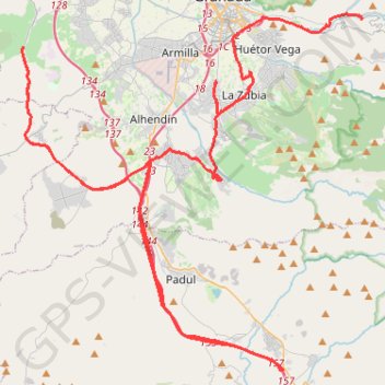
RDE_10_V-Motech_Granada
Entre Pinos Genil et Otura.
- Distance: 95.9 Km
- Elevation gain: 1,440 m
- Maximum elevation: 880 m
- Elevation loss: 1,459 m
- Minimum elevation: 631 m
Interactive map
GPS track profile
About this GPS track
Name: RDE_10_V-Motech_Granada GPS track, route, trail
Coordinates: 36.97359 -3.73315 37.16344 -3.50603
Other GPS tracks
Click on a GPS track to view route, its statistics and profile.
Southern section — European Divide Trail
France > Auvergne-Rhône-Alpes > Drôme > Valence
Distance: 2,423.8 Km • Elevation gain: 42,375 m • Maximum elevation: 2,005 m
Eurovelo 01 Spain + Portugal
France > Nouvelle-Aquitaine > Pyrénées-Atlantiques > Hendaye
Distance: 3,107.2 Km • Elevation gain: 30,592 m • Maximum elevation: 1,503 m
Southern Section — European Divide Trail
Espagne > Andalousie > Cazorla
Distance: 830.4 Km • Elevation gain: 19,253 m • Maximum elevation: 2,134 m
Stage 26: Valence to Saint-Jean-de-Fos — European Divide Trail
France > Auvergne-Rhône-Alpes > Drôme > Valence
Distance: 2,423.8 Km • Elevation gain: 42,375 m • Maximum elevation: 2,005 m
Stage 26: Valence to Saint-Jean-de-Fos — European Divide Trail
Distance: 859.0 Km • Elevation gain: 16,438 m • Maximum elevation: 1,490 m
Vila do Bispo -> Distrito 4 (495,2 km)
Distance: 1,306.4 Km • Elevation gain: 23,128 m • Maximum elevation: 2,134 m
RDE_09_GRENADE_CITY_03
Espagne > Andalousie > Comarca de la Vega de Granada > Pinos Genil
Entre Pinos Genil et Padul.
Distance: 81.7 Km • Elevation gain: 1,121 m • Maximum elevation: 847 m