Veliki_krcimir-litica
- Distance: 6.1 Km
- Elevation gain: 1,123 m
- Maximum elevation: 1,676 m
- Elevation loss: 1 m
- Minimum elevation: 553 m
Interactive map
GPS track profile
About this GPS track
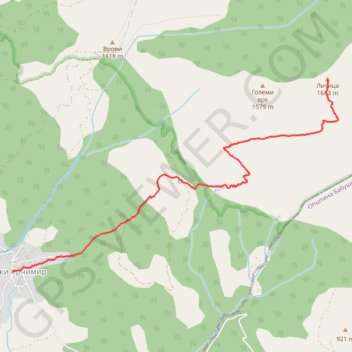
Name: Veliki_krcimir-litica GPS track, route, trail
Coordinates: 43.09865 22.20902 43.11828 22.25457
Other GPS tracks
Click on a GPS track to view route, its statistics and profile.
Tour d'Europe
France > Bretagne > Finistère > Concarneau > Landan Creis
Distance: 7,132.9 Km • Elevation gain: 44,603 m • Maximum elevation: 2,433 m
De Giromagny à Sofia
France > Bourgogne-Franche-Comté > Territoire-de-Belfort > Giromagny
Distance: 1,875.9 Km • Elevation gain: 12,108 m • Maximum elevation: 1,054 m