Pleasant - Lyttelton
Interactive map
GPS track profile
About this GPS track
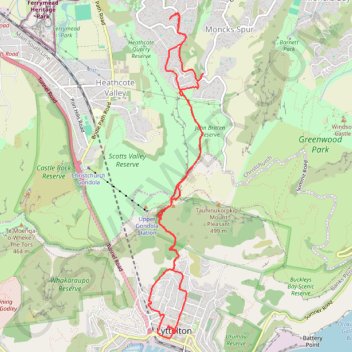
Name: Pleasant - Lyttelton GPS track, route, trail
Coordinates: -43.60338 172.71663 -43.56809 172.72503
Other GPS tracks
Click on a GPS track to view route, its statistics and profile.
Lyttelton to Sumner Walk
New Zealand > Canterbury > Christchurch City > Banks Peninsula Community > Lyttelton
Hike from Lyttelton to Sumner via Chalmers Track, Mount Pleasant Bluffs Track, Summit Road and Windsor Castle in the Tauhinu-Korokio Scenic Reserve and the Greenwood Park. #Hike #Walk #Nature #Mountain #Park #Forest #Sea #Pacific #Ocean
Distance: 7.1 Km • Elevation gain: 411 m • Maximum elevation: 418 m