Tracklog
- Distance: 13.3 Km
- Elevation gain: 269 m
- Maximum elevation: 381 m
- Elevation loss: 224 m
- Minimum elevation: 322 m
Interactive map
GPS track profile
About this GPS track
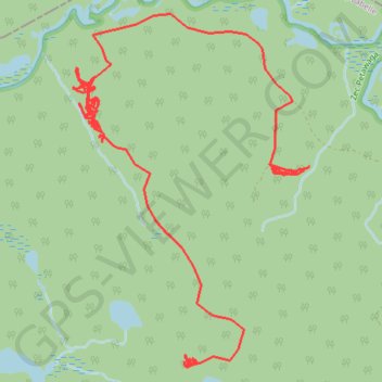
Name: Tracklog GPS track, route, trail
Start: Lac-Marguerite, Antoine-Labelle, Laurentides, Québec, Canada (47.18524 -76.03871)
End: Lac-Marguerite, Antoine-Labelle, Laurentides, Québec, Canada (47.17208 -76.04972)
Coordinates: 47.17157 -76.06172 47.19612 -76.03754
Other GPS tracks
Click on a GPS track to view route, its statistics and profile.
Tracklog
Canada > Québec > Antoine-Labelle > Lac-Marguerite
Distance: 11.8 Km • Elevation gain: 325 m • Maximum elevation: 394 m