Diamond Hill
https://fr-fr.gps-viewer.com/track-3w89m/Diamond-Hill/
- Distance: 7.0 Km
- Elevation gain: 392 m
- Maximum elevation: 435 m
- Elevation loss: 388 m
- Minimum elevation: 54 m
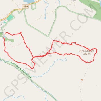
Interactive map
GPS track profile
About this GPS track
Name: Diamond Hill GPS track, route, trail
Coordinates: 53.54377 -9.94498 53.55180 -9.91085
Other GPS tracks
Click on a GPS track to view its route, statistics and profile.
Diamond Hill
Ireland > County Galway > Letterfrack
Connemara National Park. #Hike #Loop #DiamondHill #Connemara
Distance: 7.0 Km • Elevation gain: 396 m • Maximum elevation: 435 m
Trace IRELAND
Distance: 1,506.7 Km • Elevation gain: 13,359 m • Maximum elevation: 524 m
RT5-1 Rosslare - Kinsale
Distance: 2,860.3 Km • Elevation gain: 27,381 m • Maximum elevation: 420 m
RT5-1 Rosslare - Kinsale
Distance: 3,867.1 Km • Elevation gain: 36,115 m • Maximum elevation: 524 m