Mad_05_Camacha-AguasMansa-Camacha
- Distance: 13.6 Km
- Elevation gain: 784 m
- Maximum elevation: 827 m
- Elevation loss: 784 m
- Minimum elevation: 553 m
Interactive map
GPS track profile
About this GPS track
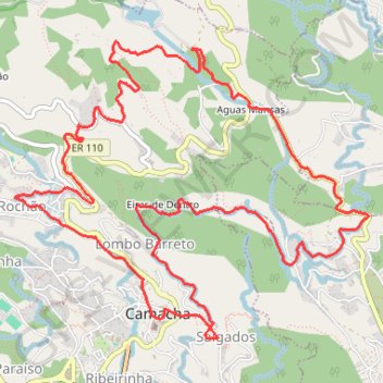
Name: Mad_05_Camacha-AguasMansa-Camacha GPS track, route, trail
Coordinates: 32.67738 -16.85706 32.69888 -16.82682
Other GPS tracks
Click on a GPS track to view route, its statistics and profile.
Monte to Camacha via Levada dos Tornos
Distance: 17.6 Km • Elevation gain: 1,245 m • Maximum elevation: 703 m