#Bike #Liptrap
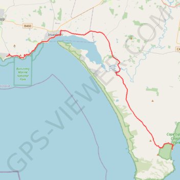
Name: Cape Paterson - Cape Liptrap Coastal Park GPS track, route, trail
Start: Cape Paterson Coastal Reserve, Surf Beach Road, Cape Paterson, Bass Coast Shire, Victoria, Australia (-38.67327 145.61583)
End: Walkerville Camping Reserve, 3, Loop Road, Walkerville North, Walkerville, Shire of South Gippsland, Victoria, 3956, Australia (-38.84172 146.00017)
Coordinates: -38.84172 145.61561 -38.62583 146.00272
Click on a GPS track to view route, its statistics and profile.
Australia > Victoria > Cowes
#Bike #Philip
Distance: 65.7 Km • Elevation gain: 522 m • Maximum elevation: 80 m
Australia > Victoria > Walkerville
#Bike #Liptrap #Wilsons
Distance: 72.2 Km • Elevation gain: 1,026 m • Maximum elevation: 205 m