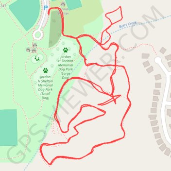
Mooresville Trail Run
- Distance: 4.2 Km
- Elevation gain: 50 m
- Maximum elevation: 272 m
- Elevation loss: 50 m
- Minimum elevation: 260 m
- Moving time: 37 m 13 s
- Moving speed: 6.8 Km/h
- Maximum speed: 12.5 Km/h
- Total time: 37 m 13 s
- Global speed: 6.8 Km/h
- Date: 23/04/24
Interactive map
GPS track profile
About this GPS track
Name: Mooresville Trail Run GPS track, route, trail
Start: Cornelius Road, Iredell County, North Carolina, 28115, United States (35.61415 -80.84379)
End: Cornelius Road, Iredell County, North Carolina, 28115, United States (35.61412 -80.84377)
Coordinates: 35.61041 -80.84404 35.61433 -80.84127
Other GPS tracks
Click on a GPS track to view route, its statistics and profile.
Mooresville Run
United States > North Carolina > Iredell County
Cornelius Road Park
Distance: 8.1 Km • Elevation gain: 69 m • Maximum elevation: 272 m