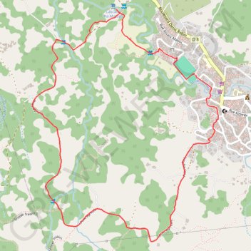
Boucle cascade Ouangani-16070964
- Distance: 4.9 Km
- Elevation gain: 174 m
- Maximum elevation: 245 m
- Elevation loss: 174 m
- Minimum elevation: 86 m
- Moving time: 1 h 37 m
- Moving speed: 3.0 Km/h
- Maximum speed: 3.2 Km/h
- Total time: 1 h 37 m
- Global speed: 3.0 Km/h
- Date: 17/01/23
Interactive map
GPS track profile
About this GPS track
Name: Boucle cascade Ouangani-16070964 GPS track, route, trail
Start: 22, Rue du Complexe Sportif, Boboka, Barakani, Ouangani, Mayotte, 97670, France (-12.84755 45.13632)
End: 22, Rue du Complexe Sportif, Boboka, Barakani, Ouangani, Mayotte, 97670, France (-12.84760 45.13638)
Coordinates: -12.85676 45.12717 -12.84399 45.13765
Other GPS tracks
Click on a GPS track to view route, its statistics and profile.
Boucle rouge-15918860
France > Mayotte > Ouangani > Coconi
Distance: 10.0 Km • Elevation gain: 304 m • Maximum elevation: 245 m
Boucle Noire-15928954
France > Mayotte > Tsingoni > Hachénoi
Distance: 51.5 Km • Elevation gain: 1,432 m • Maximum elevation: 245 m
Boucle Noire-15928954
France > Mayotte > Tsingoni > Hachénoi
Distance: 51.5 Km • Elevation gain: 1,432 m • Maximum elevation: 245 m