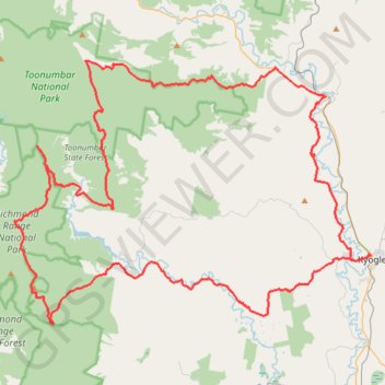
Kyogle - Peacock Creek - Bungdoozle - Iron Pot Creek - Sherwood Lookout
Interactive map
GPS track profile
About this GPS track
Name: Kyogle - Peacock Creek - Bungdoozle - Iron Pot Creek - Sherwood Lookout GPS track, route, trail
Start: 61, Ettrick Street, Kyogle, Kyogle Council, New South Wales, 2474, Australia (-28.61873 153.00230)
End: 59, Ettrick Street, Kyogle, Kyogle Council, New South Wales, 2474, Australia (-28.61874 153.00210)
Coordinates: -28.66842 152.70753 -28.47723 153.00246