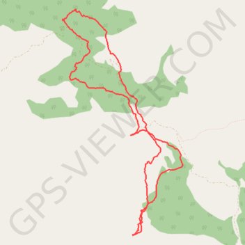
Merendero de Talembo a jbel Tazaout juanky Montes 25FEB2017 ...
- Distance: 12.0 Km
- Elevation gain: 524 m
- Maximum elevation: 1,877 m
- Elevation loss: 525 m
- Minimum elevation: 1,576 m
- Moving time: 4 h 10 s
- Moving speed: 3.0 Km/h
- Maximum speed: 7.5 Km/h
- Total time: 5 h 39 m
- Global speed: 2.1 Km/h
- Date: 25/02/17
Interactive map
GPS track profile
About this GPS track
Name: Merendero de Talembo a jbel Tazaout juanky Montes 25FEB2017 ... GPS track, route, trail
Coordinates: 35.23916 -5.11475 35.27307 -5.09274
Other GPS tracks
Click on a GPS track to view route, its statistics and profile.
Maroc en boucle depuis Tanger
Maroc > pachalik de Tanger > Tanger
Distance: 3,028.7 Km • Elevation gain: 27,253 m • Maximum elevation: 2,301 m
Ceuta -> Ouarzazat -> Ceuta espagne
Distance: 804.6 Km • Elevation gain: 9,737 m • Maximum elevation: 2,191 m