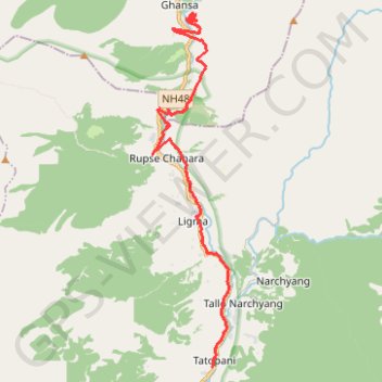
Tour Annapurna - Jour 14 - Ghasa - Tatopani
Randonnée depuis Lete. #Randonnée
- Distance: 23.6 Km
- Elevation gain: 2,225 m
- Maximum elevation: 2,244 m
- Elevation loss: 2,986 m
- Minimum elevation: 1,233 m
Interactive map
GPS track profile
About this GPS track
Name: Tour Annapurna - Jour 14 - Ghasa - Tatopani GPS track, route, trail
Coordinates: 28.49549 83.63400 28.59667 83.65897
Other GPS tracks
Click on a GPS track to view route, its statistics and profile.
Annapurna - Example
Népal > Gandaki > मनाङ > Dharapani
Distance: 167.6 Km • Elevation gain: 12,204 m • Maximum elevation: 6,020 m