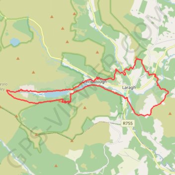
Glenealo Valley
- Distance: 25.8 Km
- Elevation gain: 937 m
- Maximum elevation: 504 m
- Elevation loss: 937 m
- Minimum elevation: 120 m
- Moving time: 5 h 59 m
- Moving speed: 4.3 Km/h
- Maximum speed: 7.7 Km/h
- Total time: 6 h 44 m
- Global speed: 3.8 Km/h
- Date: 25/11/23
Interactive map
GPS track profile
About this GPS track
Name: Glenealo Valley GPS track, route, trail
Coordinates: 52.99420 -6.39827 53.02227 -6.26528
Topography: County Wicklow topographic map
Other GPS tracks
Click on a GPS track to view route, its statistics and profile.
Trace IRELAND
Distance: 1,506.7 Km • Elevation gain: 13,359 m • Maximum elevation: 524 m
RT5-1 Rosslare - Kinsale
Distance: 2,860.3 Km • Elevation gain: 27,381 m • Maximum elevation: 420 m
RT5-1 Rosslare - Kinsale
Distance: 1,353.5 Km • Elevation gain: 15,245 m • Maximum elevation: 420 m
RT5-1 Rosslare - Kinsale
Distance: 3,867.1 Km • Elevation gain: 36,115 m • Maximum elevation: 524 m
TT22 J3 M1/06 : Port de Cork à Dublin
Distance: 358.2 Km • Elevation gain: 4,279 m • Maximum elevation: 524 m