덕룡산, 주작산, 두륜산
- Distance: 20.7 Km
- Elevation gain: 1,325 m
- Maximum elevation: 660 m
- Elevation loss: 1,309 m
- Minimum elevation: 54 m
- Moving time: 7 h 3 m
- Moving speed: 2.9 Km/h
- Maximum speed: 9.4 Km/h
- Total time: 9 h 11 m
- Global speed: 2.3 Km/h
- Date: 14/04/17
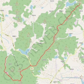
Interactive map
GPS track profile
About this GPS track
Name: 덕룡산, 주작산, 두륜산 GPS track, route, trail
Start: Baekdo-ro, Doam-myeon, Gangjin-gun, South Jeolla, 59250, South Korea (34.55463 126.71647)
End: 태웅, 174-2, 대흥사길, Samsan-myeon, Haenam-gun, South Jeolla, 59047, South Korea (34.49500 126.61715)
Coordinates: 34.46718 126.61247 34.55463 126.71647
Topography: Gangjin-gun topographic map
Other GPS tracks
Click on a GPS track to view route, its statistics and profile.
덕룡-주작-오소재(샘)
South Korea > Gangjin-gun > Doam-myeon
Distance: 12.1 Km • Elevation gain: 762 m • Maximum elevation: 462 m