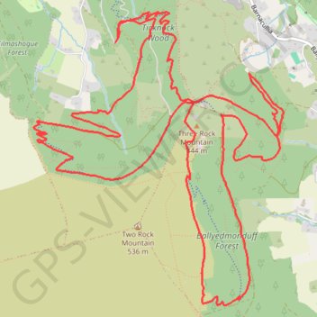
3Rock MTB
Three Rock Mountain #MTB
- Distance: 14.7 Km
- Elevation gain: 431 m
- Maximum elevation: 489 m
- Elevation loss: 431 m
- Minimum elevation: 307 m
- Moving time: 1 h 22 m
- Moving speed: 10.7 Km/h
- Maximum speed: 42.8 Km/h
- Total time: 1 h 33 m
- Global speed: 9.5 Km/h
- Date: 19/05/24
Interactive map
GPS track profile
About this GPS track
Name: 3Rock MTB GPS track, route, trail
Coordinates: 53.23352 -6.25748 53.25443 -6.22771
Topography: County Dublin topographic map
Other GPS tracks
Click on a GPS track to view route, its statistics and profile.
Route1495
Ireland > County Dublin > Shankill
Distance: 38.7 Km • Elevation gain: 949 m • Maximum elevation: 531 m
Trace IRELAND
Distance: 1,506.7 Km • Elevation gain: 13,359 m • Maximum elevation: 524 m
RT5-1 Rosslare - Kinsale
Distance: 3,867.1 Km • Elevation gain: 36,115 m • Maximum elevation: 524 m
TT22 J3 M1/06 : Port de Cork à Dublin
Distance: 358.2 Km • Elevation gain: 4,279 m • Maximum elevation: 524 m