Blessington
Interactive map
GPS track profile
About this GPS track
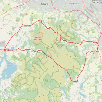
Name: Blessington GPS track, route, trail
Coordinates: 53.09025 -6.53330 53.24729 -6.13541
Topography: County Wicklow topographic map
Other GPS tracks
Click on a GPS track to view route, its statistics and profile.
Mullaghcleevaun and Black Hill Loop
Wicklow Mountains National Park
Distance: 14.1 Km • Elevation gain: 564 m • Maximum elevation: 844 m
Route1495
Ireland > County Dublin > Shankill
Distance: 38.7 Km • Elevation gain: 949 m • Maximum elevation: 531 m
Trace IRELAND
Distance: 1,506.7 Km • Elevation gain: 13,359 m • Maximum elevation: 524 m
RT5-1 Rosslare - Kinsale
Distance: 2,860.3 Km • Elevation gain: 27,381 m • Maximum elevation: 420 m
RT5-1 Rosslare - Kinsale
Distance: 3,867.1 Km • Elevation gain: 36,115 m • Maximum elevation: 524 m
TT22 J3 M1/06 : Port de Cork à Dublin
Distance: 358.2 Km • Elevation gain: 4,279 m • Maximum elevation: 524 m