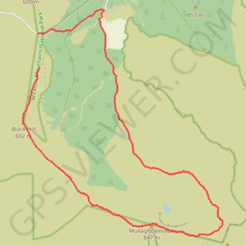
Mullaghcleevaun and Black Hill Loop
Wicklow Mountains National Park
- Distance: 14.1 Km
- Elevation gain: 564 m
- Maximum elevation: 844 m
- Elevation loss: 616 m
- Minimum elevation: 311 m
- Moving time: 3 h 12 m
- Moving speed: 4.4 Km/h
- Maximum speed: 7.3 Km/h
- Total time: 3 h 32 m
- Global speed: 4.0 Km/h
- Date: 06/06/24
Interactive map
GPS track profile
About this GPS track
Name: Mullaghcleevaun and Black Hill Loop GPS track, route, trail
Coordinates: 53.10141 -6.44553 53.14263 -6.38510
Topography: County Wicklow topographic map
Other GPS tracks
Click on a GPS track to view route, its statistics and profile.
Trace IRELAND
Distance: 1,506.7 Km • Elevation gain: 13,359 m • Maximum elevation: 524 m
RT5-1 Rosslare - Kinsale
Distance: 2,860.3 Km • Elevation gain: 27,381 m • Maximum elevation: 420 m
RT5-1 Rosslare - Kinsale
Distance: 3,867.1 Km • Elevation gain: 36,115 m • Maximum elevation: 524 m
TT22 J3 M1/06 : Port de Cork à Dublin
Distance: 358.2 Km • Elevation gain: 4,279 m • Maximum elevation: 524 m